
Exploring the Future of GIS: The Rise of Augmented Reality
The Synergy between GIS & AR:
The fusion of GIS and AR brings together spatial data and immersive technology, presenting fresh perspectives on visualizing and interacting with geographic information. This alliance enhances decision-making processes and facilitates deeper understanding in diverse domains such as urban planning and environmental monitoring. By bridging the gap between the virtual and physical worlds, the integration of GIS and AR offers innovative solutions. Let us embark on an exploration of the fascinating realm where GIS and AR collaborate.
The Role of GIS in Revolutionizing Augmented Reality for India's Future:
AR in GIS can revolutionize how we interact with geographical data in India. It combines GIS data with AR technology, projecting real-time information onto physical spaces. This benefits pedestrians, drivers, and public transportation users in navigating urban landscapes. Urban planning and infrastructure management also benefit from visualizing proposed projects. In emergencies, AR overlays expedite disaster management. Tourism experiences are enhanced with virtual guides and historical insights. The future of GIS in AR for India holds potential for informed decision-making, sustainable development, and immersive spatial interactions.
Navigating the World with GIS & Augmented Reality:
GIS in AR has immense potential, transforming how we perceive and interact with spatial information. As technology progresses, its integration goes beyond visual enhancement, providing deeper insights into our surroundings. Real-time data streaming, AI-driven insights and collaborative mapping play crucial roles in this evolving field. GIS in AR finds applications in navigation, urban planning, and disaster response, merging geographical data with augmented experiences. This fusion improves accuracy and relevance, enabling innovative solutions across industries and ushering in a new era of spatial intelligence and interaction.
Integrating GIS Data into Augmented Reality Applications:
Urban Planning and Architecture -AR in GIS allows urban planners and architects to assess proposed developments by overlaying digital models onto the real world. This enables them to evaluate visual impact, study traffic patterns, and enhance the design process. Stakeholders can also preview and provide feedback on urban development projects before construction.
Environmental Management - AR in GIS transforms environmental management by providing real-time environ- mental data. Scientists can overlay information such as air quality, soil contamination, and biodiversity onto the real world, improving monitoring and decision-making. It also enables visualization of climate change effects and aids in devising effective mitigation strategies.
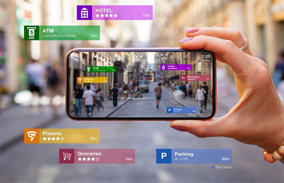
Retail and Marketing - AR in GIS can revolutionize retail by offering customized shopping experiences. By overlaying digital product details, reviews, and suggestions on store shelves, customers can make informed buying choices. AR navigation systems can also enhance the shopping experience by helping customers navigate large retail areas.
Gaming and Entertainment - The gaming industry has embraced AR technology with games like Pokemon Go and Minecraft Earth, elevating gaming to a new level. GIS in AR incorporates real-world data, creating immersive virtual worlds that blend seamlessly with the physical environment for an interactive experience.
Emergency Response and Disaster Management - AR in GIS is vital for emergency response and disaster manage- ment, It overlays real-time data onto the physical environment, enabling first responders to make informed decisions and improving coordination among response teams.
Mapping the Future &Trends in GIS for Augmented Reality
Real-Time Geospatial Data Integration:The future holds a trend of seamlessly integrating real-time GIS data into AR applications, enabling users to access up-to-the-minute geographical information.
Example: Imagine an AR navigation app providing dynamic updates on traffic, road conditions, and points of interest in real-time, enhancing the user's journey with accurate and timely information.
AI-driven Spatial Recognition: Artificial intelligence will play a pivotal role in enhancing spatial recognition within GIS-AR applications.
Example: Picture an AR app equipped with AI algorithms that can recognize and interpret complex spatial patterns, helping users identify geological features during a hike or providing historical information about landmarks.
Collaborative Mapping in AR: Collaborative mapping in AR environments is set to become a prominent trend, allowing multiple users to contribute to and interact with a shared spatial context.
Example: Think of a collaborative AR mapping platform where users worldwide contribute real-time data about environmental changes, creating a comprehensive and continuously updated global map.
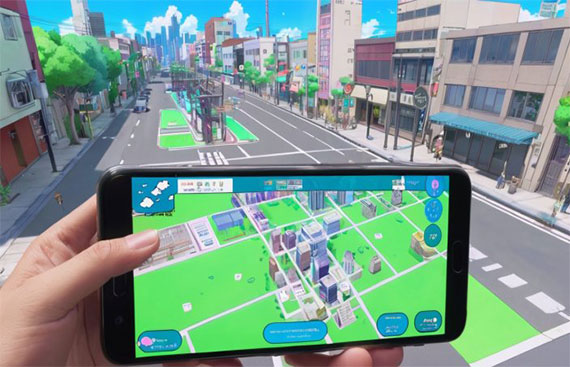
Enhanced 3D Spatial Experiences: Future GIS-AR applications will offer more immersive 3D spatial experiences, enhancing user engagement.
Example: Envision an educational AR app that transforms historical GIS data into interactive 3D visualizations, allowing users to explore and learn about ancient civilizations in a dynamic and engaging manner.
Geo-fencing and Location-Based Experiences: Geo-fencing in GIS-AR will enable location-specific interactions, providing tailored experiences based on a user's geographical location.
Example: Consider an AR retail app that uses geo-fencing to offer personalized promotions and information about products when users are in proximity to a store, creating a seamless blend of virtual and physical retail experiences.
“AR and geospatial technology have now enabled creating a real life 3D replica of an entire city, which will have a huge number of applications in terms of urban planning and infrastructure development projects” - Saurabh Rai, CEO, Arahas Technologies
Exciting Advancements in GIS and AR Technology:
Artificial Intelligence and Machine Learning - AI and ML in GIS AR create new opportunities. AI analyses geospatial data for instant insights, enhancing decision-making. ML adapts to user interactions, personalizing AR applications.
Wearable AR Devices -Wearable gadgets like smart glasses and AR headsets will boost GIS use in AR, providing a hands-free and immersive experience for interacting with geospatial data. Affordable and lightweight wearable AR devices will create new opportunities for industries and consumers.
Integration with the Internet of Things (IoT) -GIS, AR, and IoT will create a network of connected devices and data. Real-time sensor data from IoT can be viewed in AR, enabling smart cities, advanced transportation, and better environmental monitoring.
Advanced Visualization Techniques -Advancements in visualization methods like 3D modelling, VR, and holography will enhance GIS in AR. Users can engage with immersive virtual environments, improving comprehension and decision-making. This blurs the boundary between real and digital realms, resulting in transformative encounters.
Industries That Can Benefit from GIS in AR:
Urban Planning and Development -AR in GIS has the potential to transform urban planning and development projects. By visualizing proposed changes within the current environment, urban planners can make better decisions and build cities that are sustainable and livable.
Architecture and Construction -GIS and AR integration can revolutionize architecture and construction by enabling architects to visualize designs in real-world environments, improving client communication, and providing construction workers with accurate site data for enhanced safety and productivity.
Retail and E-commerce -The integration of GIS in AR enables personalized shopping experiences for retail and e-commerce customers. By projecting digital content onto products and shelves, customers can make informed decisions. AR navigation systems also enhance the shopping experience by guiding customers in large retail spaces.
Tourism and Hospitality -AR in GIS enhances tourism by providing interactive experiences for travellers. With AR applications, tourists can explore historical sites, landmarks, and cultural attractions, enhancing their understanding and engagement. Hotels and resorts can also improve customer experiences with virtual tours and personalized recommendations.
Conclusion:
GIS and AR integration can revolutionize industries like urban planning and gaming by combining geospatial data with immersive visuals. Advancements in technology, such as cloud-based solutions, AI, wearable devices, and advanced visualization techniques, will bring benefits like improved visualization, real-time data integration, en- hanced collaboration, cost and time savings, and better user experiences.
Read More News :
Trimble and IIT Kanpur team up to enhance UAV technology in India
Space Zone India Plans 2026 Rocket Launch with Cube Satellite for Edutech4Space
.jpg "Underpinning The Future Of Smart Customer Connection")

.jpg "Transforming Healthcare Through Innovative Gen AI")