

Why Google Street View was Rejected by Modi Government?
BENGALURU: Google Street View—a software application provides an interactive service where people can explore places through 360-degree, panoramic and street-level imagery—has been denied permission by the Modi government to map Indian cities, tourists spots, hills and rivers. It sums up to the roll of former controversies–Google Earth and Geospatial Bill–of approval of technology for maps in India.
Google was informed by the Home Ministry that Google’s plan to cover India through the Google Street View has been declined. A comprehensive analysis by security agencies and defence forces reasoned out that letting Google Street View to cover India would compromise India’s security interest. Security organizations seem to be cautious of allowing such image-capturing by Google provided that such planning for the 2008 terrorist attacks in Mumbai is alleged to have involved photographic reconnaissance of targets by Pakistani-American David Coleman Headley.
What is Google Street View?
Google Street View is a superfluous technology sported in Google Maps and Google Earth that provides panoramic views from positions along numerous streets all over the world. Launched in 2007, it spread across several cities in the US, expanding to include cities and rural areas worldwide. It explores places around the world through 360-degree, panoramic and street-level 3D imagery, posting everything under it online.
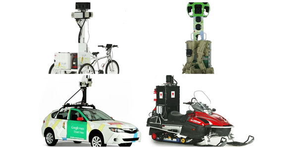
Streets with Street View imagery available are displayed as blue lines on Google Maps. It displays panoramas of stitched images. Most of the photography is done by car and the rest is done by trekker, tricycle, walking, boat, snowmobile, camel, and underwater apparatus.
Extensively used in the United States, Canada and various European countries, India had allowed for its use in few locations.
Google’s impending plans in India with Street View:
Google wanted to extend most of the Indian Territory via Google Street View. Google had on an experimental basis launched Street View in some of the tourist sites like Chinnaswamy stadium, Mysore Palace, Nalanda University, Qutub Minar, Red Fort, Taj Mahal, Thanjavur temple, and Varanasi river bank, other than a few more in partnership with the Archaeological Society of India.
Recent controversies:
This year in the month of January, Google’s online maps screening Indian defence installations, nuclear power plants and other “sensitive” locations came under the radar of Delhi High Court which asked the Centre to keep a watch on the issue and update on the same. Pathankot air base attack pushed the concern further into limelight. Totaling up the list of technology adoption related controversies, the government has proposed the Geospatial Information Regulation Bill. According to the draft bill, wrong portrayal of India’s map could land the violators in jail with tenure up to seven years and a fine reaching up to Rs 100 crore.
This measure has been conceived by the government against the set of instances where few social networking sites showed Jammu and Kashmir and Arunachal Pradesh as part of Pakistan and China respectively. However, the proposal yielded a furore, with many being speculative about its implementation.
Read Also:
